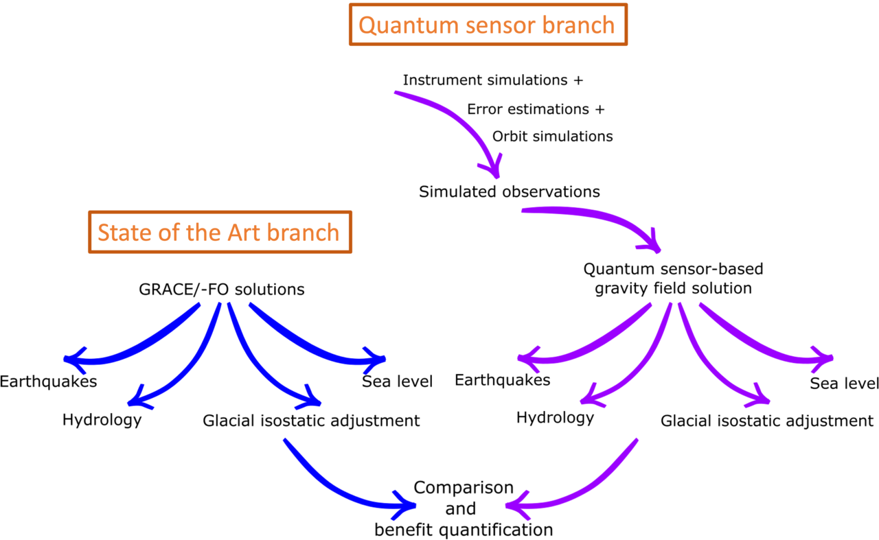
The project is structured into well separated workpackages with dedicated individual objectives and deliverables.
End-to-end satellite gravity field simulations
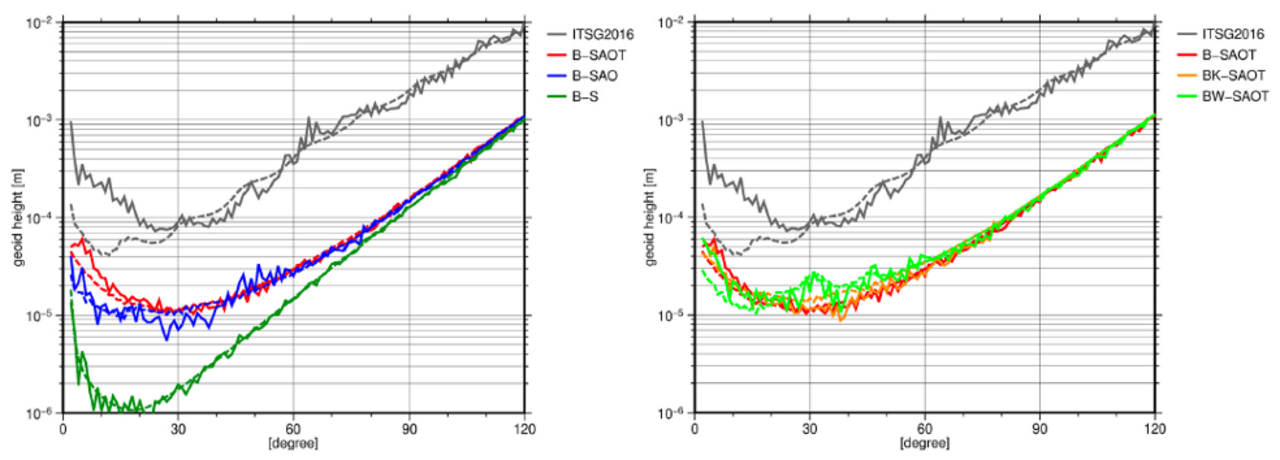
Detailed instrument and orbit simulations will be performed for different thinkable quantum space gravimetry missions. After specifying the observation concept, all required instruments will be simulated by DLR. Simulated sensor data will be inverted into global gravity fields by TU Graz under consideration of present-day (and also in the future much improved) dealiasing models. In addition, Politecnico di Milano will provide dedicated regional gravity field solutions for Southeast Asia and Japan.
- gravity field solutions for GRACE-like mission scenarios
- gravity field solutions for NGGM/MAGIC-like double-pair constellations
- gravity field solutions for quantum gravity gradiometer concepts
Responsible partners: DLR, TU Graz, Politecnico di Milano, GFZ
Tracking the seismic cycle with gravity observations
All QSG mission concepts will be tested for their ability to constrain seismic rupture modes of offshore and continental earthquakes. Improved knowledge on co-seismic slip and postseismic deformation processes will have implications for modelling stress redistribution on faults in the vicinity of plate boundaries induced by the rupture. With two different complenentary approaches, we aim to quantify the added value of QSG with respect to existing satellite gravimetry missions for tectonic research. Furthermore, we explore ways to constrain three-dimensional rheological structures from satellite gravimetry. A regional focus will be placed on Japan and Southeast Asia by estimating parameters for a co-seismic slip model for the 2011 Tohoku earthquake, assess possible afterslip contributions, and consider spatially distributed slop model for co- and postseismic gravity change calculations.
Responsible partners: University of Tokyo, Institut de Physique du Globe de Paris, University of Trieste, Waseda University
Glacial isostatic adjustment and continental ice mass balance
Glacial isostatic adjustment (GIA) describes the ongoing deformation of the solid Earth due to glacial unloading following the last glacial maximum roughly 20,000 years ago. We will perform refined modelling experiments of GIA dynamics in the European Alps and Fennoscandia with a particular focus on the consequences of the rotational feedback on GIA-induced gravity changes. The impact of small-scale GIA signatures associated with the Little Ice Age (16th - 19th century) will be assessed in detail, since it potentially biases continental ice mass loss estimates from satellite gravimetry particularly at smaller regional scales, where a future QSG mission is expected to provide new observational insights. Furthermore, we will consider alternative rheologies such as non-linear Burger's, will work on signal separation strategies for ice mass change and GIA signatures in the gravity field, and will assess residual leakage from non-cryospheric sources like ocean or hydrologic processes.
Responsible partners: AWI, National Institute of Polar Research Japan, TU Delft, University of Tokyo, University of Kyoto, Lantmäteriet, GFZ
Monitoring terrestrial water storage changes from space
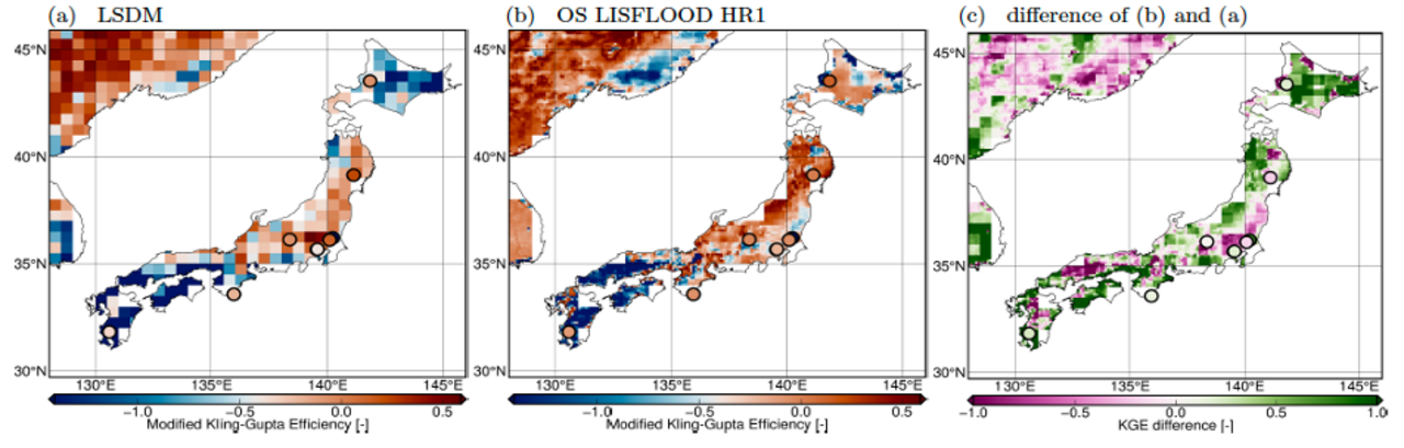
Present-day hydrologic and hydrometeorological applications are primarily limited by moderate spatial resolution of the the GRACE/-FO data record. By means of a multi-model ensemble of global land surface and hydrological models (i.e., OS LISFLOOD, W3RA, WGHM, ISBA-CTRIP), we will access the potential added value of future QSG mission concepts for the monitoring of terrestrial water storage. We will focus both on inter-annual climate variability associated with various interactively coupled hemispheric climate modes as well as on the associated hydrometeorological fluxes (i.e., precipitation, evapotranspiration, lateral runoff) that are particular important with respect to the characterization of floods and droughts. We will also aim to directly integrate future QSG data products directly into global numerical models via data assimilation with an ensemble Kalman filter approach.
Responsible partners: University of Twente, Aalborg University, University of Tokyo, Magellium, GFZ
Sea level rise and deep ocean transport variations
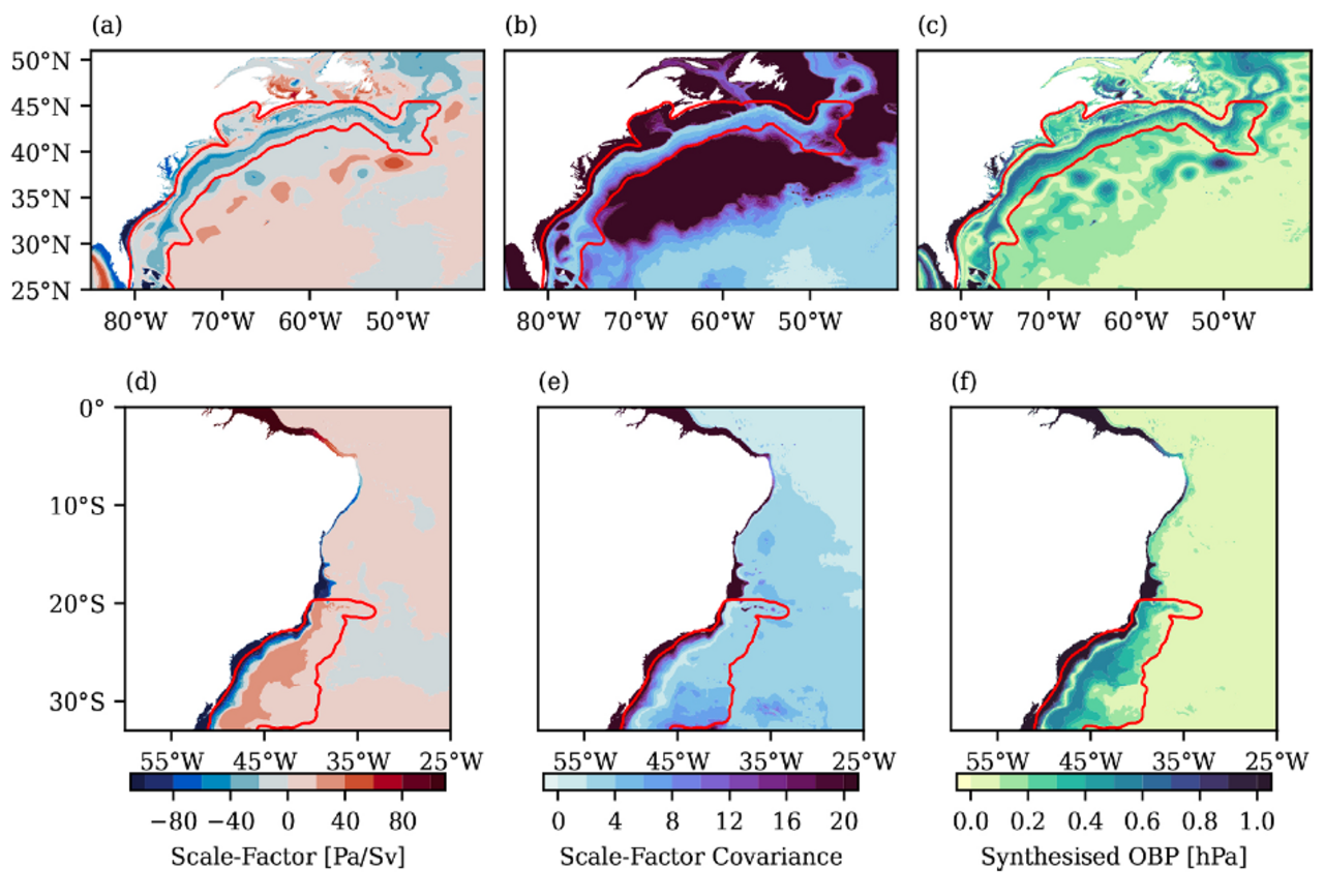
The task in this work package is assessment and illustration of the added value of a QSG mission for oceanographic and sea-level applications. In order to achieve this we recompute the sea level budget from recently reprocessed GRACE/-FO monthly gravity fields. We review and revise necessary corrections for GIA (in collaboration with work package 4) as well as the thermostatic and halosteric components based on recently published ocean reanalysis data. Furthermore, we characterize the spatio-temporal features of the ocean bottom pressure signatures associated with deep ocean transport variations and explore ways to assimilate satellite gravity data into numerical ocean models.
Responsible partners: Magellium, University of Bristol, The Japan Agency for Marine-Earth Science and Technology, GFZ
Synthesis, dissemination, and outreach
The continuous knowledge transfer from the FEATS-G consortium to the scientific community, international stakeholders, and the interested public is an important part of the project. This will be achieved through presentations at scientific conferences and the organization of dedicated working meetings. Communication with the wider public will in particular be established via the knowledge portal globalwaterstorage.info, where blog contributions about individual aspects of the progress achieved within in FEATS-G will be published. Major findings will also be submitted to peer-reviewed scientific journals and associated data repositories, so that research data elaborated in FEATS-G will become rapidly available under the FAIR principles.
Responsible partners: University of Tokyo, GFZ
QSG benefit quantification
The final project goal is the overall evaluation of the improvements achieved by using quantum satellite gravimetry methods. Shortly before the end of the project period, we will consolidate the technical feasibility and geodetic analysis options of such future missions. We aim to quantify the added value for the various geophysical applications considered earlier and consolidate the findings into a white paper. All partners involved in the project will contribute to this overarching goal of FEATS-G.